|
The Shweli Suspension Bridges
There have been three suspension bridges at this site, two of which still stand. The first was completed by the British in 1936.[S01] It was destroyed by MAJ Robert Petit, 1st Air Commando Group, flying a P-51B on 21 Apr 1944.[S02]
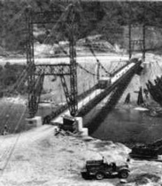
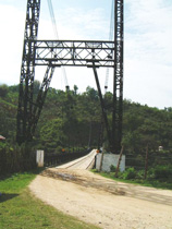
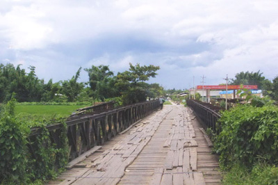
The US Army 209th Engineers is recorded as having installed a new 450 foot (137m) Bailey suspension bridge across the Shweli, close to the first site, in Mar 1945:[S03] That bridge still stands at N23°48.87 E97°37.92:
 |
 |
| After completion 1945[S04] |
Uploaded 17 Sep 2008[S05] |
A reasonable question to ask is: if the Shweli suspension bridge was not completed until March 1945, how did Allied forces advancing down the Ledo Road cross the Shweli River in January 1945?
Seagrave's Burma Surgeon Returns, Shuya's Blog 进入中国的车队如何跨国瑞丽江?, and Romanus & Sunderland's Time Runs Out in CBI provide a not altogether consistent detailed answer which boils down to this:
January through March was typically in the dry season, which enabled fording various streams and rivers.
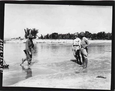
05-06 Jan 1945: Nationalist China's 112th Regiment forded the Shweli directly across to Namhkam to facilitate the entry of the 90th Regiment into Namhkam on 15 Jan.[S06]
12 Jan 1945: Nationalist China's 90th Regiment forded the Shweli about 5 km SW of the destroyed Shweli bridge.[S07]
17 Jan 1945: Gordon Seagrave crossed the Shweli using a bamboo raft ferry service from Mansawn. Note the bamboo deck of the ferry (raft) behind Seagrave.[S08]
General Sun Li-jen and accompanying party of dignitaries crossed using another small ferry. This photo in shuya的BLOG shows how small:[S09]
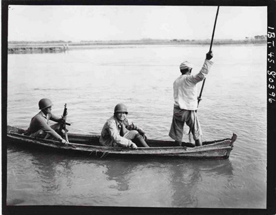
Seagrave recorded that he had been given priority in crossing the river (over General Sun Li-jen): hence General Sun did not welcome Seagrave as shown above. Rather the two photos above were staged later at the requests of the numerous news photographers accompanying them.[S10]
18 Jan 1945: US Army engineers completed a pontoon bridge across the Shweli, which apparently served as crossing point for the Ledo Road's intended overland cargo traffic until the suspension bridge was completed three months later.[S11]
2009: A new suspension bridge, 600 ft (183m) long, was opened at N23°48.87 E97°37.91, about 230m (750 ft) upstream (northeast) of the old WWII bridge.[S12] The old bridge remains in place.
A related matter, that of errors in US Army maps' descriptions of the status of the Shweli suspension bridge after 1945, is discussed here.
|
Other airstrips in the area
At the beginning of the war, there were two airfields in the Loiwing area; by the end of 1944, both were unusable because of Allied bombing. But in the early months of 1945, the Allies added at least four more in association with the Ledo Road:[AS01]
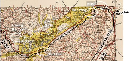
Immediately behind the advance of Allied forces progressing down the road from Myitkyina were crews scraping out temporary airstrips for aircraft to support the crews repairing and improving the roadways and laying a fuel pipeline. Per an unofficial 879th Engineer Aviation Battalion website (emphasis added):[AS02]
The main body of the Northern Combat Command Forces had pushed on some fifty miles south . . . and a field capable of taking C-46 traffic was urgently needed. . . . with the continued advance of the "Marsmen" we followed through to Loi Wing [China], location of an old Curtis [sic] Assembly Plant, on to Panghkam [Burma], and thence to Mu-Se [Burma], building the necessary support fields en route.
The battalion provided this note of clarification:[AS03]
. . . The series of fair-weather airstrips which we were building were useful only as intended; that is, for the close support of combat forces pushing forward. When the first rains of the monsoons came they revert back to the marshy rice lands from which they are formed. . . . At the time of our advance, during the dry winter months, this earth, which is a sea of mud during the rest of the year, was caked hard. With the . . . small rises cut away and the brush cleared, a relatively suitable landing field is made in a minimum of time which will stand up under quite strenuous conditions for the brief period used before the offensive moves beyond . . . .
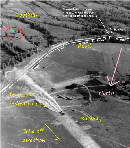
In the general Loiwing area, temporary runways were put in near Panghkam, Namhkam, and Man Wing (this in Muse). The existing, but damaged, runway at the CAMCO factory was not used presumably because it needed substantial repairs, plus it was separated from the Ledo Road by both a 10 km (6 mi) distance and the Nam Wan (River).
The location of the strip at Panghkam is lost (though there appear to be several elongated paddy fields, any one of which might been an airstrip).
However, that at Namhkam is still visible and included in one tour company's offering, presented as pictured here:[AS04]
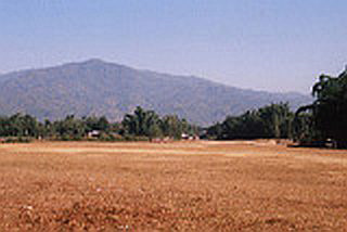
That field may be the straight line feature 460m (1500 ft) long seen here in this oblique aerial view at N23°50.36 E97°42.15 with headings 10/28. The two circles at the west end of the feature are probably present-day helicopter landing zones:[AS05]
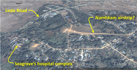
Contradicting that identification is the airstrip's 40m elevation above the Ledo Road. That differential would have hindered the purpose of the airstrip --- supporting improvements to the Ledo Road and construction of a paralleling pipeline. Conversely, favoring this site was the nearness of Seagrave's hospital site, similarly elevated: note the road connecting the runway with the east-west road leading to the hospital complex. The ability to medevac casualties to his medical facility would have been an advantage to Allied command. Further, Seagrave was held in high esteem by the Allied command who might simply have gifted him the airfield.
Continuing northeast from Namhkam, the next major town was Muse, in which two of three major features from the Ledo Road period still exist:[AS06]
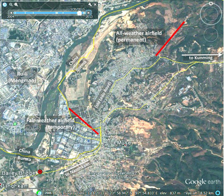
Continuing northeasterly from Namhkam along the right-of-way which had been the Ledo Road, there is a curiosity at the outskirts of Muse: a Bailey Bridge, left over from the end of WWII:[AS07]
Bailey Bridge at Muse (N23°58.275 E97°52.670)
Further along the road, 2.5km (1.5mi) easterly, had been located Muse's temporary "fair weather" airstrip, Man Wing, which had been described in some detail by the 879th:
. . . the work of converting the paddies at Mu-Se was a relatively small detail. . . .
This fair-weather strip, constructed in the only naturally level spot in the valley floor by our Company "B" detachment, had its approach from over the Shweli River and ended abruptly some four thousand feet away where the foothills crowded in. It was so situated as to be in the path of treacherous cross-winds existent when only a breeze was blowing and became the jinx-field for those flying jockeys of Combat Cargo . . . who had to make the stop to unload personnel, supplies, and pipe for the petroleum engineers laying the "big inch" to Kunming. . . .
On 6 February [1945], the C-47 bringing part of our S-3 Section into Mu-Se to survey lines for our job there, overshot the fair-weather field, crashed into the bamboo hedging the south end of the strip, and burned . . . Another six or eight planes were to crash here before we completed the large runway . . .
The fair weather airstrip is pictured here:[AS08]
.jpg)
Installed in the river flat, its location is only identifiable from the photo because of the distinctive alignment of the perimeter road --- the Ledo Road, which followed the river high water shoreline.[AS09]
Today that distinctive configuration is preserved in an intercepter drainage channel, which forms part of the China-Burma border. The one-time river flat has been filled in and heavily developed as the major border crossing point, Jiegao:[AS10]
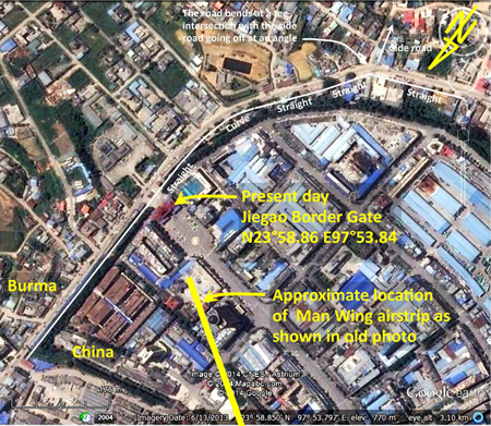
North here is page down, left, to coincide with photo above.
Following construction of the temporary airstrip, a 4,500 ft (~1,400m) permanent "all weather" runway was constructed just north of Muse at N24°00.53 E97°55.09 (runway headings: 04-22); though no longer active as a fixed wing facility, the airstrip is still visible from the air. Circles at its southwest end suggest its continued use as a helicopter facility:[AS11]
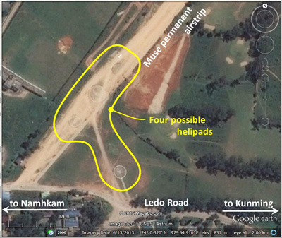
The reason for building a permanent runway here is unknown: possibly it was to provide air access for the "105-Mile" intersection with the old Burma Road at Mong Yu. The road north from that intersection goes immediately into narrow valleys not suitable for siting airstrips. The Muse runway is not listed in "The Hump" network of airfields.
|
Irregular Burma-China boundary near Shweli River
On 06 Oct 2007, ick53993 wrote to the Yuku Loiwing thread in part:[B01]
It seems the Shweli River changes its course frequently. I can see the old river bed on Google map.
The 1944-dated map below shows the area where the Shweli River valley broadens between the towns of Muse and Namhkam. Within that wider valley, the river name Nam Mao (circled in red twice in the map) applies to two separate, but roughly parallel, waterways in existence in 1926 (the date for the topographical information used to fashion the map). The broader, more southerly, waterway, color-coded blue, generally demarcates the current border. The lesser, more northerly, waterway of the same name is color-coded green. The black line denotes the current border when that border is not tied to the broader waterway. Note that when the border does diverge, it does so between the two named Nam Mao waterways within the valley:[B02]
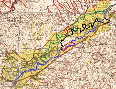
High resolution image available here.
The above image helps explain the peculiar border in this later (1967) and smaller scale map which more clearly shows the border in brown:[B03]
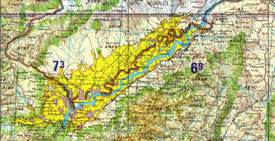
High resolution image available here.
Notice that Stilwell, the road, is misspelled on the later map with two double Ls as Stillwell.
The meanderings of the Shweli River (Nam Mao) within the valley as shown above, coupled with the unusual irregularities of the current border, imply that the border followed a river course sometime before the 1926 topo data that was used in making this Survey of India map. A firm basis for that assumption is available in an 1894 agreement (Convention) between the UK and China which reads in part:[B04]
[progressing easterly, the boundary] reaches the Shweli River at its junction with the Nammak [River] [N23°49.4 E97°37.7] . . . It will then follow the course of the Shweli River, and where the river bifurcates [the junction with the Nam Wan (N23°50.7 E97°38.7)], it will follow the more southerly of the two branches [ie, the Shweli, as the Nam Mao, not the Nam Wan] . . . until it reaches a point near the eastern end of the loop which the river forms opposite to Meung Mao [Mengmaozhen N23°59 E97°51] . . . .
But the course of the Shweli River that was recorded in the Convention may actually have been dated as early as 1886: a Convention in 1886 had agreed to establish the border between British Burma and China:[B04a]
The frontier between Burmah and China to be marked by a Delimitation Commission.
So, to state the obvious at this point, by 1926, the date for the topographic data on the Survey of India Hsenwi map, the Shweli had apparently meandered sufficiently to produce the substantial disparity between the current border and the river course, that disparity continuing very visible today on, for example, Google Earth.
And there was a road associated with that Convention of 1894:
The Baptist mission among the Shan reported for 1893 (emphasis added):[B05]
The borderline between English and Chinese territory, the [Nam Mao or Shweli River], usually called here the NamKham River splits the valley lengthwise, it is definitely settled with treaty right to build a direct road to Bhamo across Chinese soil."
Wikipedia explains:[B06]
The region belonged to China but the British colonial administration built a road in 1894-1897 between this frontier town [Namhkam] and Bhamo by the Ayeyarwady [Irrawaddy] River in Kachin State, a distance of 56 miles, for Chinese muleteers in order to benefit from the border trade. The town was rented to the British in 1897 by Qing Dynasty (similar to the New Territories of Hong Kong).
But it was a little more complicated than that:
Per the wording of the Convention 1894, noted above, a road between Bhamo and Namhkam was already in existence when the document was signed in 1894. The road's origin is not stated, though it might well have been for the purpose Wikipedia describes. As the boundary was reckoned, a section of the road from the Shweli River extending north about nine miles was in Chinese territory.
In 1897, the boundary was moved by an Agreement[B07] modifying the Convention so that the road was entirely within British Empire control. Britain agreed to pay "rent" to China for the surrounding area, not just the town of Namhkam, presumably per a clause in the Convention 1894 which stated in part:[B08]
. . . any alterations in the alignment which the Joint Commission may find it necessary to make shall be based on the principle of equivalent compensations, having regard not only to the extent, but also to the value, of the territory involved.
So, while no money apparently changed hands with the original Convention, compensation was provided for the boundary adjustments that the Agreement subsequently provided.
Notes:
Wikipedia's 56 mile road distance between Bhamo and Namhkam is a bit light: Survey of India maps give a mileage of 71, while a US Forces publication gives a distance of 67.[B09]
It is possible that the muleteer road, probably allowing greater slopes, could have provided a more direct and somewhat shorter access between the two locations. That "old mule road" about which Seagrave writes (below) is believed to be visible on the Survey of India Hsenwi map and can be seen to join the Bhamo-Namhkam Road near the FFP (Frontier Force Post) at Namhkai (sp?).[B10]
Seagrave mentions an "old mule road" to Panghkam:[B11]
Colonel Brown . . . came to me with Colonel Sliney for help on a reconnaissance to locate the best short cut to the old mule road to Panghkam.
. . . [at] the fifty-second mile [N23°54.8 E97°32.4 (as before)], . . . We were at the entrance to the short cut and in sight of the hospital buildings at Namhkam.
The alignment of that section of the "old mule road" is basically that of the "Tank Road" shown on Seagrave's map.
|
Location of Gordon Seagrave's Hospital
Ge Shuya presents this photo of one of Seagrave's hospital buildings, constructed of his favored "cobblestones", as it appears now:[H01]
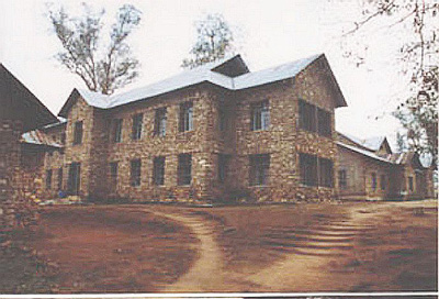
The hospital complex appears to be at N23°50.4 E97°41.7.
|
Development of a date for the NARA photo of the CNAC aircraft named Chungking / Chongqing
The photo on page 2 of a DC-2 passenger aircraft is in the collection of the US National Archives and Records Administration (NARA) on-line in Wikimedia. Information available about the photo, ie, the aircraft operator and the location, are recorded in the title as CNAC and Loiwing respectively. CNAC is known to have had DC-2s in its fleet. The location can be confirmed by what appears to be the CAMCO facility at Loiwing in the background. Additional information is available in the name on the aircraft's nose, 庆重 (read right to left as Chungking or Chongqing)[C00]. The problem is the possible date of the photo.[C01] To answer that, the following chronology of possibly relevant information was assembled:[C02]
1936: CNAC received a new DC-2, assigned it the number 29 and the name 四川 (Sze Chuen, Sichuan, Sicuan, or Szechwan)[C02a].
Dec 1937: No 29 was renamed Chungking before it made CNAC's first Hong Kong-Chungking flight. So the old name, Sze Chuen, was "retired" in Dec 1937.
Early 1938: No 29 went down for lack of parts, was eventually cannibalized for its parts, and finally decommissioned. It was decommissioned as the Chungking. So the name, Chungking, was effectively "retired" in early 1938.
24 Aug 1938: Kweilin Incident: CNAC DC-2 aircraft No 32 with name Kweilin, another passenger liner, in trying to evade aggressive IJAAF aircraft, landed in a river not far from Hong Kong. The IJAAF aircraft then proceeded to repeatedly strafe the aircraft, eventually sinking it and killing 14. Wreckage was subsequently recovered and aircraft rebuilt.
Spring 1939: at Loiwing, the CAMCO facility, including runway, was opened.
Nov-Dec 1939: After No 32 had been rebuilt, its identity was changed to reduce possible superstitious concerns by passengers. It was renumbered as No 39, the name Kweilin was permanently "retired", and the name Chungking was taken out of retirement for the new No 39.
26 Oct 1940: the CAMCO facility at Loiwing was bombed by the IJAAF and put out of service.
29 Oct 1940: No 39 was destroyed on the ground at Changyi Airport with nine fatalities after repeated strafing by IJAAF aircraft, resulting. As a result, the name Chungking was also permanently "retired" by CNAC effectively on this date.
Key events in the above review were:
The name Chungking had been used:
1. From December 1937 to early 1938 (as No 29)
2. From Nov-Dec 1939 to 29 Oct 1940 (as No 39)
Loiwing airfield
1. Activated in Spring 1939
2. Rendered unserviceable on 26 Oct 1940.
The earliest date is controlled by the completion of the rebuild of the second Chungking, as No 39, in Nov-Dec 1939. The Loiwing runway was already operational on this date.
The latest date is controlled by the destruction of the CNAC aircraft, Chungking, on 26 Oct 1940. The Loiwing runway was still active on this date.
So any picture of a CNAC DC-2 named Chungking at Loiwing had to have been taken between Nov-Dec 1939 and 26 Oct 1940. And the only CNAC aircraft with the name, Chungking, during that period was No 39.[C03]
|
|
Emphasis may be added, as relevant, to various excerpts quoted here.
S01.^ 1936: Seagrave, Gordon, Burma Surgeon (NY: Norton, 1943), pp 76-79 do not specify the year, but it can be deduced from the text, emphasis added:
In the last year of our second term of service, . . . The Lashio-Namkham road was also continued over an enormous suspension bridge to Bhamo, the head of shipping on the Irrawaddy.
1937 --- We came back from America . . . .
Depending on the departure and return dates, plus the duration of the stay in the US, the date could have ranged from 1935 to 1937.
S02.^ MAJ Robert Petit: Y'Blood, William T, Air Commandos Against Japan: Allied Special Operations in World War II Burma (Annapolis: Naval Institute Press, 2008), p 115.
The British Army had made an effort during the evacuation of the area to destroy the bridge with explosives. It was unsuccessful (See Peter Tindley, who has died aged 94 and Northern Shan States Battalion BFF).
On 02 Jun 1943, the bridge was reportedly heavily bombed and damaged, but prematurely in light of the Allied continued effort to destroy it for an additional ten months (Chicago Daily Tribune, 03 Jun 1943, p 5)
Lieuwe Montsma bored through the abnormally dark Google Earth view of the bridge area and pointed out to me the older bridge hidden in the gloom. The bridge I had assumed was the Bailey suspension bridge was actually the newest bridge, less than ten years old.
S03.^ 11 March: Ge Shuya in进入中国的车队如何跨国瑞丽江?
15 Mar 1945: CBI Order of Battle: 209th Engineer Combat Battalion; The Ledo Road.
S04.^ Photo extracted from A 450 foot Bailey cable bridge spans the Shweli River and enhanced with IrfanView.
An excellent photographic record of the US Army's 1945 construction of the Shweli River bridge is available here: Shweli River Bridge Construction. A thanks to Lieuwe Montsma for the link.
S05.^ Photo of Shweli bridge between Kachin and Shan State, looking from south bank, linked through Google Earth. Enhanced with IrfanView.
S06.^ 05-06 Jan 1945: Romanus & Sunderland, Time Runs Out in CBI () p 127; or possibly earlier per Seagrave, BSR, ibid, p 230.
S07.^ 12 Jan 1945: Time Runs Out, ibid, Map 7, p 124 (narrative is ambiguous).
S08.^ 17 Jan 1945: Seagrave, BSR, ibid, pp 240ff.
Photo: 西格雷夫医生(左)也坐小船过江,孙立人将军(右)和另外一位美国军官在岸边等待。这里显然就是Mansawn(曼哨)。in shuya的BLOG's 进入中国的车队如何跨国瑞丽江?; enhanced with IrfanView.
S09.^ 孙立人坐小船从Mansawn读过瑞丽江进入南坎地区 in shuya的BLOG's 进入中国的车队如何跨国瑞丽江?: enhanced with IrfanView.
S10.^ Seagrave, ibid, pp 240‑241.
S11.^ 18 Jan 1945: Seagrave, ibid, p 248; 330th Engineer Regiment, UNIT HISTORY, China-Burma-India Theater.
S12.^ Per happy footprints.
AS01.^ Part of Hsenwi (93 E) No. F-47 B, Provisional GSGS [Geographic Service of the General Staff] 4218 (Survey of India), as the 3rd Ed 1944-AMS 2 (topo data 1926). Image extracted and enhanced with IrfanView, and annotated using Microsoft Publisher, by author.
AS02.^ 879th Engineer Aviation Battalion: China-Burma-India Theater of World War II. Loiwing and Panghkam are not on the Namhkam-Bhamo Road; in order to pass through them, the unit would appear to have used the "shortcut" pointed out by Seagrave, then taken a "side trip" to Loiwing, fording the Nam Wan out and back, and then on to Panghkam.
AS03.^ 879th Engineer Aviation Battalion, ibid.
AS04.^ A Study Trip to the Ledo Road. Image enhanced by author using Irfanview.
AS05.^ Airstrip pointed out by Lieuwe Montsma, email 1436 hrs, 27 Dec 2014.
Google Earth image, an oblique view, captured with Gadwin PrintScreen, enhanced with IrfanView, and annotated by author using Microsoft Publisher.
AS06.^ Google Earth image, captured with Gadwin PrintScreen, enhanced with IrfanView, and annotated with Microsoft Publisher by author.
AS07.^ Bridge near Muse. Enhanced with IrfanView by author.
AS08.^ US Army in World War II: Pictorial Record. The War Against Japan. Section V: China-Burma-India, p 429.
AS09.^ US Army in World War II: Pictorial Record, ibid. Annotations in color by Lieuwe Montsma; those in white by author using Microsoft Publisher.
AS10.^ Google Earth image, captured with Gadwin PrintScreen,
enhanced with IrfanView, and annotated using Microsoft Publisher by author.
AS11.^ Google Earth image, captured with Gadwin PrintScreen, enhanced with IrfanView, and annotated using Microsoft Publisher by author.
Lieuwe Montsma suggested that the circles probably represent helicopter services (email 1436 hrs 27 Dec 2014).
B01.^ ick53993 post on 1536hr 06 Oct 2007 on Yuku Warbirds' Loiwing thread --- since removed.
B02.^ The image is a composite of portions of Provisional GSGS [Geographic Service of the General Staff] 4218 Series (Survey of India), Hsenwi (93 E) No. F-47 B (3rd Ed 1944-AMS 2 (topo data 1926)) and Bhamo (92H) No. G-47 T (4th Ed 1944-AMS 2 (topo data 1908-1912)).
Image enhanced with IrfanView, and two maps joined and annotated using Microsoft Publisher, by author.
B03.^ Part US Army Map Series 1501 Air, Sheet NF 47-2, Edition 3, Hsenwi, Burma, China. PDF image captured with Gadwin PrintScreen, and enhanced using IrfanView by author.
B04.^ CONVENTION between Great Britain and China relative to Burmah and China, Boundaries, &c, Signed at
London, March 1, 1894. In Hertslet's China Treaties . . . in force on 1st January, 1908 (London: HMSO, 1908), pp 99‑109. Hereafter Convention 1894.
B04a.^ CONVENTION between Her Britannic Majesty and His Majesty the Emperor of China relative to Burmah and Tibet. Signed at Peking, 24th July, 1886 and ratified in London on 25 Aug 1887. In Hertslet's China Treaties . . . in force on 1st January, 1908, ibid, pp 88‑90
B05.^ Baptist mission among the Shan, Ch 2, p 56.
B06.^ Wikipedia article: Namhkam (Shan State).
Seagrave, ibid, p 203: a map entitled "Myitkyina to Namkham", p 203, shows both a "Namkham Mule Road" and a 'Border Trail", though neither joins with better roads shown.
Bhamo (92 H) No. G-47 T, Provisional GSGS [Geographic Service of the General Staff] 4218 (Survey of India), as the 4th Ed 1944-AMS 2 (topo data 1908-1912; road classification Aug 1944) shows a network of roads which probably includes the subject road.
B07.^ AGREEMENT between Great Britain and China modifying the Convention of march 1, 1894, relative to Burmah and China. Signed at Peking, 4th February 1897. In Hertslet's China Treaties . . . in force on 1st January, 1908, ibid, pp 113‑119. Unfortunately the map which may be associated with this Agreement is of too small a scale to show the detail needed to check actual border in that area (ibid, opposite p 113).
B08.^ Convention, ibid.
B09.^ Hsenwi (93 E) No. F-47 B, Provisional GSGS [Geographic Service of the General Staff] 4218 (Survey of India), as the 3rd Ed 1944-AMS 2 (topo data 1926; 'major communications' verified 1940). Hereafter Hsenwi map.
US Forces publication: Stilwell Road
B10.^ Hsenwi [93 E], ibid.
B11.^ Seagrave, Gordon, Burma Surgeon Returns (NY: Norton, 1946), pp 230-231.
H01.^ 西格瑞夫医院(今天).jpg at shuya的BLOG, enhanced with IrfanView by author.
C00.^ Wikipedia Chongqing.
C01.^ The reason is actually part of a larger problem: see Talk:Kweilin_Incident: Photograph of the actual aircraft.
C02.^ The chronology is based on a discussion in Axis History Forum: Identification of aircraft, between L1E1 (who wishes to remain anonymous) and myself in late Feb 2015.
C02a.^ Wikipedia Sichuan.
C03.^ The conclusion that the photo of the aircraft was that of CNAC's No. 39, named Chungking / Chongqing was confirmed by Gregory Crouch, author of China's Wings (NY: Bantam, 2012), per his emails of 2312 hrs 02 Mar 2015 and 1154 hrs 03 Mar 2015.
|